


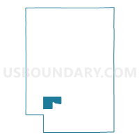
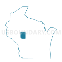
HEWETT - T 1 Voting District, Clark County, Wisconsin
About
Outline

Summary
| Unique Area Identifier | 692804 |
| Name | HEWETT - T 1 Voting District |
| County | Clark County |
| State | Wisconsin |
| Area (square miles) | 17.93 |
| Land Area (square miles) | 17.69 |
| Water Area (square miles) | 0.24 |
| % of Land Area | 98.66 |
| % of Water Area | 1.34 |
| Latitude of the Internal Point | 44.57596540 |
| Longtitude of the Internal Point | -90.74810800 |
Maps

Graphs
Select a template below for downloading or customizing gragh for HEWETT - T 1 Voting District, Clark County, Wisconsin


Neighbors
Neighoring Voting District (by Name) Neighboring Voting District on the Map
- FOSTER - T 1 Voting District, Clark County, WI
- HEWETT - T 2 Voting District, Clark County, WI
- MENTOR - T 1 Voting District, Clark County, WI
- PINE VALLEY - T 1 Voting District, Clark County, WI
- PINE VALLEY - T 2 Voting District, Clark County, WI
- SEIF - T 1 Voting District, Clark County, WI
- WESTON - T 1 Voting District, Clark County, WI
Top 10 Neighboring County Subdivision (by Population) Neighboring County Subdivision on the Map
- Pine Valley town, Clark County, WI (1,157)
- Weston town, Clark County, WI (699)
- Mentor town, Clark County, WI (584)
- Hewett town, Clark County, WI (293)
- Seif town, Clark County, WI (172)
- Foster town, Clark County, WI (95)
Top 10 Neighboring Unified School District (by Population) Neighboring Unified School District on the Map
- Neillsville School District, WI (6,443)
- Osseo-Fairchild School District, WI (5,541)
- Alma Center School District, WI (3,066)